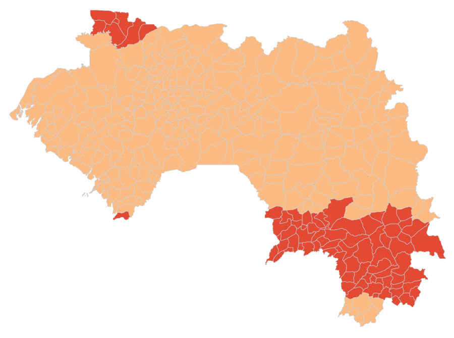
Solar calibration coverage by sub-prefecture, Guinea
Calibration coverage status and expected residual uncertainty (p80) by sub-prefecture of Guinea, without the calibrated values, published in a dedicated layer. Shows where the calibration is robust and where local instrumentation is recommended.
Simple
- Date (Publication)
- 2026-09-12
- Citation identifier
- kuma_ouvert:sous_prefectures_couv
- Keywords
-
-
coverage
-
calibration
-
residual
-
confidence
-
solar energy
-
Guinea
-
sub-prefecture
-
-
GEMET - INSPIRE themes, version 1.0
-
GEMET - Concepts
-
Gazetteer administratif de la Guinée
-
- Labe
- Nzerekore
- Boke
- Kindia
- Faranah
- Kankan
- Mamou
- Conakry
- Labe
- Tougue
- Mali
- Koubia
- Lelouma
- Macenta
- Nzerekore
- Yomou
- Beyla
- Gueckedou
- Lola
- Gaoual
- Boke
- Fria
- Koundara
- Boffa
- Coyah
- Dubreka
- Telimele
- Forecariah
- Kindia
- Kissidougou
- Dabola
- Dinguiraye
- Faranah
- Kerouane
- Kouroussa
- Kankan
- Mandiana
- Siguiri
- Dalaba
- Pita
- Mamou
- Conakry
- Use limitation
-
Open data, reusable with attribution.
- Access constraints
- Other restrictions
- Other constraints
-
CC BY 4.0 licence: https://creativecommons.org/licenses/by/4.0/ Attribution required: Solar Atlas of Guinea, operated by Kuma Science.
- Aggregate Datasetindentifier
- d89ceb01-52ef-5c6f-b9bc-7736e22fa9f0
- Association Type
- Cross reference
- Aggregate Datasetindentifier
- ba6740c3-e2cf-5a7d-81a6-5da8aa1b598a
- Association Type
- Cross reference
- Aggregate Datasetindentifier
- b28af72f-630d-5d93-ac98-32f59eba5b80
- Association Type
- Cross reference
- Aggregate Datasetindentifier
- 6cff48b7-9c38-5710-96fe-eef3ddf81839
- Association Type
- Cross reference
- Aggregate Datasetindentifier
- a1bc196e-11cd-5e41-bc9a-89fde39c6ee6
- Association Type
- Cross reference
- Spatial representation type
- Vector
- Language
-
fre
- Topic category
-
- Climatology, meteorology, atmosphere
))
- Begin date
- 1991-01-01
- End date
- 2020-12-31
- Reference system identifier
- EPSG:4326
- Distribution format
-
-
GeoJSON
(
RFC 7946
)
-
GeoJSON
(
RFC 7946
)
- OnLine resource
-
kuma_ouvert:sous_prefectures_couv
(
OGC:WMS
)
WMS visualisation
- OnLine resource
-
kuma_ouvert:sous_prefectures_couv
(
OGC:WFS
)
WFS download
- Hierarchy level
- Dataset
Conformance result
- Date (Publication)
- 2026-09-12
- Explanation
-
The transposition to the module plane and the thermal correction rely on an engine verified by comparison with the reference library pvlib. This conformance concerns the computation. The accuracy of the resource against ground measurements is established by the calibration residual.
- Pass
- Yes
Quantitative attribute accuracy
- Name of measure
-
GHI calibration residual at the 80th percentile
- Measure description
-
The GHI calibration residual against ground measurements, at the 80th percentile, ranges from 2.4 to 5.8 % across sub-prefectures (median 3.4). The per-sub-prefecture value is carried in the layer.
Quantitative result
- Value
- 3.4
Quantitative attribute accuracy
- Name of measure
-
DNI calibration residual at the 80th percentile
- Measure description
-
The DNI calibration residual, at the 80th percentile, ranges from 6.0 to 16.2 % across sub-prefectures (median 6.5), reaching two to three times the GHI residual in the cloudy south. The direct resource is less bankable. The per-sub-prefecture value is carried in the layer.
Quantitative result
- Value
- 6.5
- Statement
-
Extent and quality of the solar calibration by sub-prefecture: expected residual (p80) and graded confidence, without the calibrated values. NASA POWER satellite corrected against the ground stations of the ESMAP/WAPP 2021-2023 campaign.
- Description
-
NASA POWER satellite irradiance.
- Description
-
Seasonal adjustment based on the donor stations.
- Description
-
Floor set on the nearest donor station.
- Description
-
Uncertainty propagation to the published residual.
- Included with dataset
- No
- Feature catalogue citation
- File identifier
- 2589d532-fac8-5426-8c33-a5a9aee40480 XML
- Metadata language
-
fre
- Character set
- UTF8
- Hierarchy level
- Dataset
- Date stamp
- 2026-09-19T12:17:40
- Metadata standard name
-
ISO 19115:2003/19139
- Metadata standard version
-
1.0
Overviews
Spatial extent
Provided by